European Waters
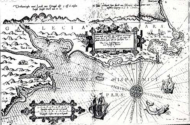
This map covers European waters from the Eastern Baltic to Straits of Gibralter. It was the first printed sea map of the region, especially noteworthy for the inclusion of depth-soundings, seen as small numbers near the coasts. This map dates from 1584, it is Dutch, by Waghenaer.
Back to:
[ Map Index Collection ]
If you have any questions or would prefer to order over the phone Call/Text (805)358-4040 fax us at (805)493-5937 or [ E-Mail us webmaster@swcountry.com. ] We ship all over the world. Guaranteed satisfaction.
[ CLICK HERE TO JOIN OUR MAILING LIST ]
CLICK ON THE FOLLOWING LINKS FOR MORE QUALITY PRODUCTS.
![]() | [ Index of items ]
| [ Metal Wall Sculptures ]
| [ Forged Iron Stone County Collection ]
| [ Beds ]
| [ General Lighting Collection ]
| [ Native American Indian Artifacts ]
| [ Music Collection ]
| [ Gift guide ]
| [ Forged iron Acccessorie Cowboy Collection ]
| [ Oils, Lithographs and Prints ]
| [ Metal wall art ]
| [ Log Pole Furniture Collection ]
| [ Office Accents ]
| [ Bath-room accessories ]
| [ J.C. Schahrer Western furniture ]
| [ Forged Iron Kitchen Accent ]
| [ Iron Fire Place Tools ]
| [ Bath-room Accents ]
| [ General Lighting, Chandeliers, Fixtures and Lamps ]
| [ Hair on Cow Hide Leather ]
| [ fine leather Living Room Collection. ]
| [ Index of items ]
| [ Metal Wall Sculptures ]
| [ Forged Iron Stone County Collection ]
| [ Beds ]
| [ General Lighting Collection ]
| [ Native American Indian Artifacts ]
| [ Music Collection ]
| [ Gift guide ]
| [ Forged iron Acccessorie Cowboy Collection ]
| [ Oils, Lithographs and Prints ]
| [ Metal wall art ]
| [ Log Pole Furniture Collection ]
| [ Office Accents ]
| [ Bath-room accessories ]
| [ J.C. Schahrer Western furniture ]
| [ Forged Iron Kitchen Accent ]
| [ Iron Fire Place Tools ]
| [ Bath-room Accents ]
| [ General Lighting, Chandeliers, Fixtures and Lamps ]
| [ Hair on Cow Hide Leather ]
| [ fine leather Living Room Collection. ]